Wednesday, May 9, 2012

Massanutten Special

Massanutten is a synclinorium located within the Valley and Ridge province and is the dominant topographic and geologic structure of the Shenandoah Valley of Virginia, extending for approximately 160 km along a northeast strike.  It is in this region where we start our geology field trip for Structure.

The range bisects the Shenandoah Valley and is divided into northern and southern sections. 
The northern section consists of 3 roughly parallel ridges, forming 2 valleys. The wider, main valley, is called Fort Valley, while the smaller one is known as Little Fort Valley. The ridges of the northern section converge at New Market Gap. The southern section consists of a series of closely gathered ridges, separated by precipitous creek gorges.


The geology of the Massanutten Mountains is dominated by sandstone and supported by shale. Erosion of the underlying shale in some areas of the mountain caused the sandstone to break and slide to form talus slopes. Generally the Massanutten Sandstone is folded into a syncline, and it outcrops at the ridge tops. The synclinal structure of the mountain gives it its characteristic shape.
A syncline is a downward-curving fold, with layers that dip toward the center of the structure. On a geologic map, synclines are recognized by a sequence of rock layers that grow progressively younger, with the youngest layers at the fold's center or hinge followed by progressively older layers outward. Therefore, a reverse sequence of the same rock layers occurs on the opposite sides of the hinge. 

On the first day of our fieldtrip we headed to a location that I had never been to or heard of, for that matter—the Garth Run outcrop.  It is located four miles Northwest of Wolftown, Virginia, off of State Route 665—Garth Run Road within the Blue Ridge Province of Virginia.  When I first got to this spot, it just looked like a bunch of granitic rocks.  But, upon closer inspection I immediately recognized the Grenville Basement Complex by the characteristic anorthosite and blue quartz rock depicted below.

This gave me an indication of where it was in the stratigraphic time record.  Upon closer inspection, there were several other things going on here that would give me clues as to what events took place that aided in the deformation of these rocks.  The rocks at Garth Run consist of Granite, Meta-Granite, and gneiss and zones of ductile shear that cut through Garth Run indicating a high strain zone.  My mission here was to find evidence to support the hypothesis that this area was affected by two different orogenies—the Grenville orogeny, approximately one billion years ago and the Alleghenian orogeny approximately 300 million years ago.  Furthermore, to support the idea that this is a thrust dominated shear zone.  Below are some of my findings.  

Here, we found S and C fabrics as annotated in the picture above, which indicate as sinistral sense of shear.  Although not visible in this picture, lineations were present in this outcrop and I found two different sets of foliation.  
One set of foliation that was easy to see was one the rock by the creek.  Here, the water scours out the sides of these boulders leaving the surface fresh and easy to view.   Although hard to see due to the extreme amount of poison ivy,  there are rocks there that show progressive deformation into ultra-mylonite.  These classmates trudge through regardless of the poison ivy.
  

Many of the boulders were strongly foliated and augens gneiss with progressive deformation was present.  These Augens were primarily feldspathic and by the degree of deformation I classified the majority of them as Mylonite.  

We piled back into the vans after collecting all the great information that this outcrop could tell us and headed off to the Swift Run stop.

We began our journey to the next outcrop by bushwacking a little over 1000ft from the road.  I had no idea where we were just that my trust was in my professor.  As we walked, several rocks stood out to me and upon closer inspection they turned out to be amigdules.  Amigdules are commonly found in basalt where vesicles form.  These vesicles fill with solution and eventually crystallize.  Below is an excellent example of one that we found on the trail.  The presence of this suggests there was volcanic activity, possibly from the Catoctin during the rifting event of the opening of the Protoatlantic. 


The Swift Run Formation rests disconformably above the Greenville basement complex.  The rocks here are primarily sedimentary.  Blue quartz sediment is abundant in the sedimentary rocks here and this most likely came from the Grenville Basement as it was being eroded.  These sediments are arkosic sandstone conglomerates and appear to be deposited in a basin environment.  I also observed primary features such as these large ripped up clasts throughout the outcrop and cross bedding with coarse to fine layering.


Here are some nice examples of ripped up clasts embedded in the Swift Run Formation

Swift Run Formation- bedding showing coarse to fining upward.

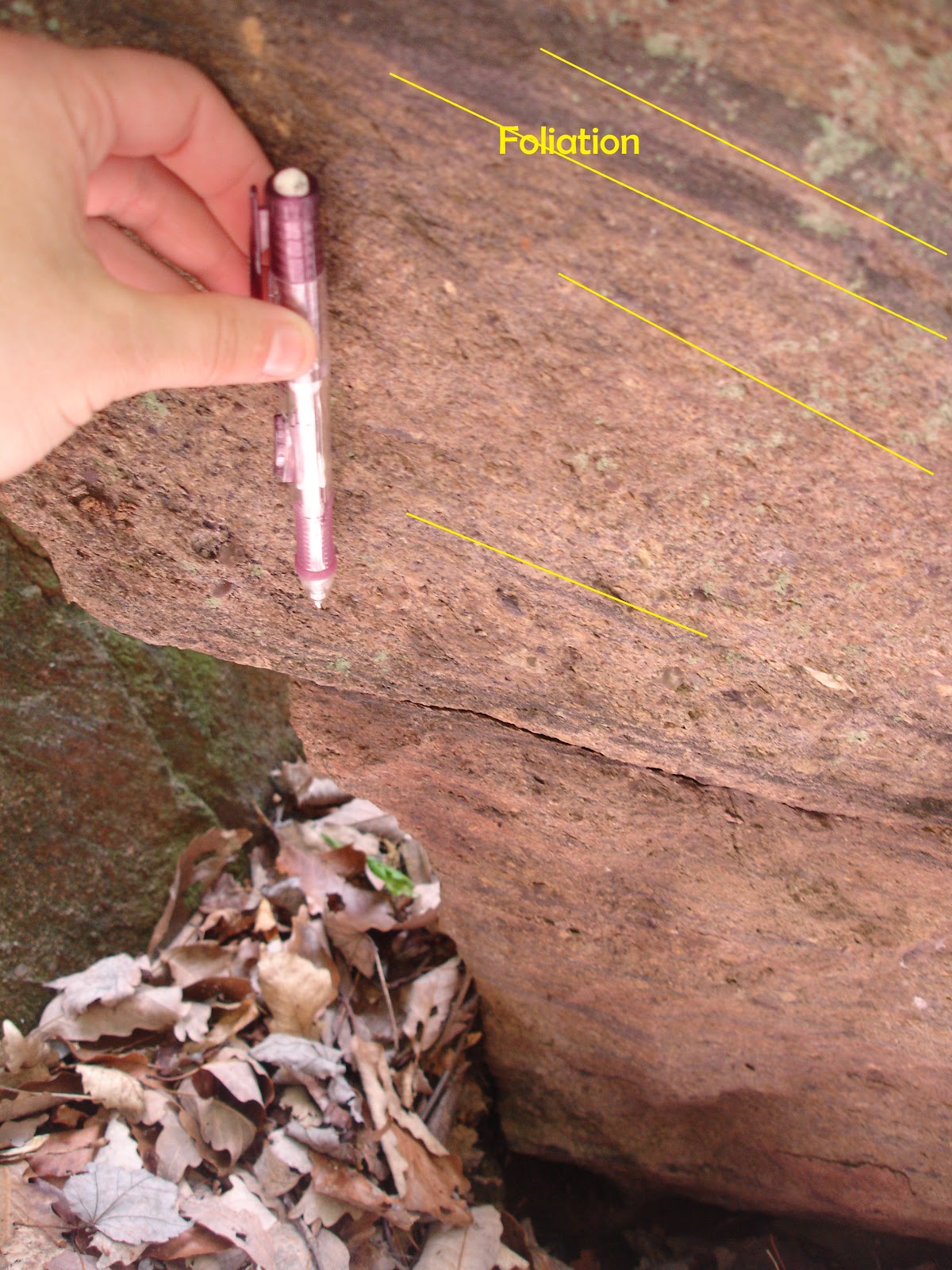
Foliation is shown in the picture below.  Folding within these beds were a secondary feature most likely caused from the Alleghenian orogeny.  These tectonic events took place approximately  325 – 260 Mya when Africa slammed into North America.  The collision formed a huge mountain chain that rivaled the Himalayan Mountain Range exerting massive stress that caused tilting and fracturing and folding.  What remains of these mountains is explained in my Thoroughfare Gap blog here http://whattherockstellus.blogspot.com/2012/04/thoroughfare-gap-va.html


Pictured below is and example of sinistral parasitic folding from tectonic forces compressing from the west.  This is characterized by ductile shear rather than brittle shear.


Bedding here (below) measured approximately N10E, 75° and  the cleavage measured N75E, 80°

Chilhowee Group Quick Stop
At our next stop, we me up with Dr. Rick Diecchio to explore an outcrop of the Chilhowee Group primarily the Weverton and the Harpers.  For me, these stick out like a sore thumb.   The Weverton is a meta-quartzite that is typically grey to tan in color with some areas of conglomerate facies.  These sediments were laid down in succession during the breakup of Rodinia at the end of the Ediacaran and up into the Early Cambrian.  The Harpers is characteristic of a dark phyllite meta-siltstone.  The original sediment would most likely have come from a lagoon setting where mud predominated as deposition of sediments were laid down while the Iapetus Ocean sea level rose. Siltstone implies that these deposits came from a quieter environment.  In time, metamorphism of this sediment took place forming shale layers.  Below we can see the fissile nature of this formation.
Annotated below are bedding layers that are possibly part of a bouma sequence.  This package is grading from coarse to fine.


Here, we also took measurements of foliation and bedding and came up with this stereonet.  This is a classic example that we see in the Blue Ridge where thrusting develops this type of axial plane cleavage.

Skyline Drive
Antietam Sandstone is quite abundant in certain parts of skyline drive and even used as decorative borders along lookout points.  It was here that the following photos were taken. I have already discussed the Antietam Formation in detail in my Thoroughfare Gap blog page but I will recap here.   This formation lies atop the Harpers Formation and is very easy to spot due to the lovely skolithos tube fossils that are abundant within the meta-sandstone matrix.  The Antietam Formation is part of the Chilhowie group (discussed above) which represent a passive margin while sea level rose during the Early to Middle Cambrian.  The pictures below tell us that a tectonic event must have taken place after this formation had been deposited due to the tension gashes of the quartzite veins.  I have annotated the shear direction in the pictures below.  These tension gashes form at right angles (perpendicular) to the direction of maximum stretching.


These are not found in the original location and are thus considered float so a direction at which the forces came to cause this deformation is unknown.  However, we can see that relative to the skolithos, this deformation affected all of the grains including the skolithos.  Let’s take a look.  The first picture just shows the skolithos from the top view looking down as though you were looking at the sea floor.


And here below, the skolithos are deformed.
...and more deformation in tension gashes on Antietam Sandstone


Franklin Overlook was our next quick stop but one of my favorites.  This is because we were able to learn a little more about the Catoctin Formation.  Throughout my college geology courses, the Catoctin often gets mentioned but never more than that.  The Catoctin Formation was so named for the Catoctin Mountain.  This formation comprises lava flows that happened during the breakup of Rodinia. 
 Here, while the rifting was occurring, feeder dikes cut up through the crust filling some areas with meta-basalt aka “Greenstone”.  The swift run also continued to fill in low areas and consequently some of these basalts are rich in felsics, rhyolite and meta-tuff.  Evidence found in the Catoctin Formation show meta-sedimentary rocks primarily of interest is the black phyllite which we interpret as being from an old lake.  Here at this outcrop, we find a strange conglomerate rock from the Catoctin and seek to understand its origins.  The green matrix is primarily epidote with large clasts of quartz, basalt, and amygdule abundant basalt.  The clasts are quite angular which must have been immature when deposited.  We decided this must be epidotized volcanic breccia from a pyroclastic flow that later became metamorphosed.


We headed along Skyline Drive until we pulled over for a quick little hike along the Limberlost Trail.  Here we found another opportunity to see some of the lovely Catoctin…this time in the form of Columnar Basalt.  So as we step back in time, Rodinia was breaking up and all around the land would have been a naked landscape which was smothered in lava flows.  As these flows began to cool, hexagonal jointing began to take place.  Here is a picture of the columnar basalts of the Limberlost Trail. 


 Now most of the time, columnar jointing fractures in nice 120° pieces.  But here something must have happened to offset this jointing.  My suspicion was that the Alleghenian orogeny had a hand in deformation of these basalt columns.  Further measurements concluded that indeed there was a force coming from the east and that force deformed not only the angles between the joints as much as 25°+/-, but that the arrest lines were actually tilted offset from perpendicular to their normal position (annotated in picture above.)

In addition, there were three sets of columnar basalt units at this outcrop.  Being so close together, I felt they should all have received close to the same amount of movement and deformation.  But it was not so.  I labeled them as A, B, and C units and discovered the following:
Unit A was tilted at N10E, 64°
Unit B was tilted at N2E, 76°
Unit C was tilted at N2W, 60°


On a steronet they look like this.  Why they are not similar is beyond me for now.  I will make another visit to this location soon and see what I can piece together.

We all headed back down the trail with Callan testing us all along the way with rocks from the ground. Back in the Vans, we headed off to see some really nice examples of feeder dikes along skyline drive.  The contact between the outcrop and the dike was contrasted well as depicted in the picture below.  Notice the dark mafic microcrystalline characteristic of the basalt.  These dikes were striking at N25E and dipping at roughly 65° which gives insight to the orientation of breakage in this area where they opened up.  Scientists study feeder dikes such as these to try and understand the relationship of age and cross cutting relationships in terms of paleomagnatism.  The samples taken here will help to establish the position of Virginia on Earth at the time of Rodinia. 


More basalt columns were spotted along the trail up to Comptons Peak.  Growing up in the Columbia Basin area in Washington State, columnar basalt is quite abundant and I have to say I wasn’t too impressed.  But, given the fact that there are not too many areas in the east with this type of structure, I am rethinking my opinion.  One of the neat things at this outcrop that I noticed for the first time with basalt is the convex and concave nature on the faces of the columns where they have fractured and broke off.  More than likely, these happened along the arrest lines and I am left to ponder as to why this happens and is there a pattern.  

As we headed down the mountain, we began to get the feeling that it was going to rain.  Weather reports stated there was a chance of snow coming our way.  By the time we hit the next stop, wet weather was upon us.  We scrambled to Veach Gap where we saw many anticlines poking out from the rock outcrops.  All were facing in the same general direction and all were symettrical based on our measurments.  Slickenlines were found on the site indicating there was a fault nearby.  The rain made the rocks very wet and we soon found ourselves in a dangerous situation.  We quickly scrambled back to the vans where we made the decision to cut the trip short.  Here is a picture of one of these amazing anticlines in the middle of nowhere.


Thursday, April 19, 2012

Thoroughfare Gap, Va

On our latest Geology field trip we went to Thoroughfare Gap (TG) just outside of Gainsville, VA . TG is a gap in the Bull Run Mountain through which Broad Run, I-66, and railroads pass.  To the east, lies the Piedmont Province.  Bull Run Mountain lies on the eastern most edge of the Blue Ridge Province.  The Blue Ridge Province extends from Pennsylvania to Georgia along the eastern edge of the Appalachian Mountains.  Here Precambrian and Paleozoic rocks were uplifted and folded due to several episodes of orogenic events.  These events caused extensive tilting of the strata in this terrain.
 For this field trip, we are going to try to gather conclusive data to answer the questions: “how did these strata get tilted, and from what direction did the continental collision come?”  To do this we are going to gather measurements of the dip of the beds we find, the strike and dip of the joint sets, and any other structural components that are significant enough to use to support our hypothesis.
Another question we will attempt to answer on this field trip will be “what happens to rocks as they are folded?”  We should be able to find evidence of folding due to the position of TG which lies on the edge of two provinces, with the Blue Ridge Province being the one that is being thrust up.  But, before attempting to answer these questions a little history lesson is in order.

About 440 to 480 Mya, during the Middle Ordovician Period, the Tachonic orogeny began to take place.  This mountain building event began to change the Appalachian landscape when an advancing oceanic plate collided with, and began subducting beneath the North American craton.  This subduction led to the birth of the Appalachian Mountains and thrust faulting over the preexisting sedimentary rock.  Over time, erosion took its toll on the mountains.  Over the next 250 million years several more orogenies took place helping to shape the North American craton. 

At 325 – 260 Mya the Alleghenian orogeny took place when Africa slammed into North America.  The collision formed a huge mountain chain that rivaled the Himalayan Mountain Range exerting massive stress that caused tilting and fracturing.  On this field trip we will search for evidence of this Alleghenian orogeny by finding evidence from folding, faulting, and tilted strata showing the direction of force from the continental collision. 
 It was a beautiful morning at TG when we arrived on site.  We followed the main trail up to the lookout.  The rocks in this area were mostly from that of the Weaverton Formation which is part of the Chilhowee Group.  This group includes the Weaverton, Harpers, and the Antietam Formation the latter of which is not present at TG.  These sediments were laid down in succession during the breakup of Rodinia at the end of the Ediacaran and up into the Early Cambrian.  The Weaverton is a meta-quartzite that is typically grey to tan in color with some areas of conglomerate facies. Some rocks along the path showed pebble sized grains of blue quartz embedded into the meta-quartzite matrix.  This blue quartz is characteristic of erosional sediment from the Grenville Basement rocks.

This photo outlines the plane of foliation and lineation with a close-up of the stretched pebble conglomerate. Here, the quartz pebbles are indicative of Plane Strain.
Quartzite is derived from sandstone.  Sometimes it is sedimentary and other times it can be metamorphic.  Orthoquartzite is a sedimentary type that is formed at low temperatures and pressures by fluids that contain high silica.  The silica-rich fluid that surrounds the sand grains recrystalizes and forms metaquartzite which is the kind of rock we find here in the Weaverton.

As stated before, the Harpers Formation lies atop the Weaverton.  The Harpers is characteristic of a dark phyllite meta-siltstone.  The original sediment would most likely have come from a lagoon setting where mud predominated as deposition of sediments were laid down while the Iapetus Ocean sea level rose. Siltstone implies that these deposits came from a quieter environment.  In time, metamorphism of this sediment took place forming shale layers.  


The fissile nature of these rocks along the path is quite evident.  We stopped to observe a sample and found some nice folding on it.  Let’s take a look.


Here we can see the fissile nature of the phylitte where it breaks into sheets.  This sample is actually kinked.  A nice example of Kink folding.  The stripes are the phylitic orientation 1 where we see a succession of flat, tilted, flat, tilted which is based on flow.  We do not see conjugate pairs here.  Notice how the orientation 1 are all lined up parallel and are at approximately the same angle.  Also interesting to note is the amount of sheen on the surface.  This is due to small grains of mica and graphite which are phylosilicates.  Remember though, phyllite is shale that has been metamorphosed and the particles have in a sense fused together giving it that glittering surface.

The Antietam Formation has recently become a fascination for me.  It lies atop the Harpers Formation and is very easy to spot due to the lovely skolithos tube fossils that are abundant within the meta-sandstone matrix.  I was told that the Antietam Sandstone was not found here at TG and I searched everywhere to find evidence that it existed at one time even making my way back to the site several more times.  I still have not found it but there should be evidence of it in float somewhere.  Perhaps during the folding event the entire formation slid off into the depositional basin.   Below is a picture of my own personal sample (found on the outskirts of Skyline Drive).  Notice the lovely skolithos (worm tubes).


All three of these formations make up the Chilhowee Group and represent a passive margin while these were being deposited.  Here is a great example of an illustration by Gathright (1976) showing the deposition and likely environments that helped to form the Chilhowee Formation.

Along the path, as many times as permitted, I sought for opportunities to take measurements of strike and dip with my handy Brunton compass.  I have constructed a few steronets to determine the direction from which the forces came that may have caused the tilting we see in all of the rocks along this mountain.    This steronet characterizes just the strike and dip of the beds for this mountain.
 The trend here shows that most of the beds are dipping toward the east taking into consideration that some of the measurements may have a certain level of inaccuracy due to the combining of data by students on varying degrees of skills in taking strike and dip measurements-- aka human error.  This coincides with publications today on the tectonic history of this region.  Although we have not taken measurements on the other side of the Blue Ridge Province, where a large thrust fault marks the boundary between the Valley and Ridge Province and the Blue Ridge Province, we know from literature that the Blue Ridge is a large overturned anticline.  Here is a great diagram from James Madison University that helps show the overturned anticline in cross section. 
Notice the Chilhowee group and how much of the surface has been eroded away.  I have constructed a topographic cross section using GeoMapApp software to show the actual height to distance.  Here we can observe just how much erosion has taken place over the last 260+/- million years. 


 To the East lies the Culpepper Basin.  It is one of a series that spans the boundary between the Blue Ridge Province and the Piedmont along the length of the Appalachian Mountains.  This basin formed during the Mesozoic during a tensional tectonic event where a rift valley was formed.  This limb of the rift valley failed with the other limb forming the Atlantic Ocean. Pangea was now in a broken state.   As this rift valley was opening up, large conglomerate sediment and lime mud began to deposit layer after layer in a wedge at the base of the uplifted mountains to the west.  On this field trip we were able to find some evidence of this in what is known as the Waterfall Conglomerate.  Below is a picture from the College of William and Mary showing the faults on both sides of the rift basin.  Later, dikes cut through this basin as shown in the diagram in red as a cross cut relationship to the sedimentary basin rock.


The Waterfall Conglomerate pictured below is made up of several large clasts of limestone and quartz cobbles mixed in a lime-mud matrix.  This was tested with my handy HCL bottle back in 2011 while I was out there for the first time.  Also within this matrix I found volcanic rocks and an unusual rock that had layers of limestone interbedded with several hues of varying colors that appeared to be bedding.  It all fizzed when tested with HCL.  But, where did this come from?  Sadly, its not to be solved today. The rocks I was looking for in the Waterfall Conglomerate were pieces of the Antietam Sandstone but still no sign of my skolithos friends.


Moving along the railroad through TG heading west, there is an outcrop where a lovely display of phyllite lies atop the Weaverton.  Due to the Weavertons resistivity to compression, it retained its blockiness in contrast with the Phyllite above it.

Farther down  the tracks continuing westward, the stratigraphy of the outcrops change into almost entirely the Weaverton Formation.  The rocks are that characteristic  orthoquartz arenite we discussed earlier but there is the faint traces within the rock that appears to be bedding.  The bedding is very thin laminations of a dark colored mineral that tend to all run parallel to each other.  Controversy as to whether or not this is actually bedding is discussed in further detail in a blog by Callan Bently at http://blogs.agu.org/mountainbeltway/2011/02/22/beds-and-veins-in-the-weverton/.

Throughout this bedding, we find quartz veins that cut into the beds.  We took measurements of these quartz veins so that we could throw them into a stereoscope for more interpretation.  So basically, the bedded sandstone layer was deposited in a horizontal fashion and lithified.  Then, these rocks were tilted to a certain degree where they reached a critical point and eventually failed.  This failure led to jointing which became filled with a silica-rich hydrothermal fluid.   This fluid had crystallized into milky quartz.  Whats great about this process is that it’s like a time marker in a sense relative to the bedding.   Then, the bedding now with quartz inclusions, continued to be tilted.  The final stage is that these same rocks have now undergone another stage in jointing.  This is what we see today.


Here is a picture of the joint sets we discussed earlier.


Liesegang banding was found out on some of the rock surfaces.  It is observed by a discoloration of the rock by a rust color and by this sort of water-stain appearance with rings of iron oxides.  This is evidence left behind from a water table that once existed.  Although I could not get a picture of the actual liesegang on site, here is an example of it on sandstone from a different site.


So overall, we were able to answer the question as to which direction the compression came from that caused the folding based on the data from strike and dip that we collected.  We also input these values into a steronet to show that the general trend of tilt was towards the east.  The second question we answered was as to what happens to the rocks when they are folded.  Due to the folding, the rocks became tilted and eventually failed creating joints.  These primitive joints left a scar infilled with milky quartz.  Later, as these rocks continued to fold, they underwent a second jointing process--the one we see today in the photos above.  The geologic history of  TFG is complicated yet facinating.  Understanding how these forces helped to shape our region can be understood by putting all the pieces together and then we are able see what the rocks are trying to tell us.

Many plumose structures in the Thoroughfare Gap area.  Plumose structures record fracture propagation direction in rocks. These structures are a feather-like pattern of ridges and grooves on the fracture surface. Below we can see a few examples of how they can be identified.


Here is another example of plumose structures, only in this example we see concentric ribs, also known as arrest lines.