Another question we will attempt to answer on this field trip will be “what happens to rocks as they are folded?” We should be able to find evidence of folding due to the position of TG which lies on the edge of two provinces, with the Blue Ridge Province being the one that is being thrust up. But, before attempting to answer these questions a little history lesson is in order.
About 440 to 480 Mya, during the Middle Ordovician Period, the Tachonic orogeny began to take place. This mountain building event began to change the Appalachian landscape when an advancing oceanic plate collided with, and began subducting beneath the North American craton. This subduction led to the birth of the Appalachian Mountains and thrust faulting over the preexisting sedimentary rock. Over time, erosion took its toll on the mountains. Over the next 250 million years several more orogenies took place helping to shape the North American craton.

At 325 – 260 Mya the Alleghenian orogeny took place when Africa slammed into North America. The collision formed a huge mountain chain that rivaled the Himalayan Mountain Range exerting massive stress that caused tilting and fracturing. On this field trip we will search for evidence of this Alleghenian orogeny by finding evidence from folding, faulting, and tilted strata showing the direction of force from the continental collision.

It was a beautiful morning at TG when we arrived on site. We followed the main trail up to the lookout. The rocks in this area were mostly from that of the Weaverton Formation which is part of the Chilhowee Group. This group includes the Weaverton, Harpers, and the Antietam Formation the latter of which is not present at TG. These sediments were laid down in succession during the breakup of Rodinia at the end of the Ediacaran and up into the Early Cambrian. The Weaverton is a meta-quartzite that is typically grey to tan in color with some areas of conglomerate facies. Some rocks along the path showed pebble sized grains of blue quartz embedded into the meta-quartzite matrix. This blue quartz is characteristic of erosional sediment from the Grenville Basement rocks.

Quartzite is derived from sandstone. Sometimes it is sedimentary and other times it can be metamorphic. Orthoquartzite is a sedimentary type that is formed at low temperatures and pressures by fluids that contain high silica. The silica-rich fluid that surrounds the sand grains recrystalizes and forms metaquartzite which is the kind of rock we find here in the Weaverton.
As stated before, the Harpers Formation lies atop the Weaverton. The Harpers is characteristic of a dark phyllite meta-siltstone. The original sediment would most likely have come from a lagoon setting where mud predominated as deposition of sediments were laid down while the Iapetus Ocean sea level rose. Siltstone implies that these deposits came from a quieter environment. In time, metamorphism of this sediment took place forming shale layers.

The fissile nature of these rocks along the path is quite evident. We stopped to observe a sample and found some nice folding on it. Let’s take a look.

Here we can see the fissile nature of the phylitte where it breaks into sheets. This sample is actually kinked. A nice example of Kink folding. The stripes are the phylitic orientation 1 where we see a succession of flat, tilted, flat, tilted which is based on flow. We do not see conjugate pairs here. Notice how the orientation 1 are all lined up parallel and are at approximately the same angle. Also interesting to note is the amount of sheen on the surface. This is due to small grains of mica and graphite which are phylosilicates. Remember though, phyllite is shale that has been metamorphosed and the particles have in a sense fused together giving it that glittering surface.
The Antietam Formation has recently become a fascination for me. It lies atop the Harpers Formation and is very easy to spot due to the lovely skolithos tube fossils that are abundant within the meta-sandstone matrix. I was told that the Antietam Sandstone was not found here at TG and I searched everywhere to find evidence that it existed at one time even making my way back to the site several more times. I still have not found it but there should be evidence of it in float somewhere. Perhaps during the folding event the entire formation slid off into the depositional basin. Below is a picture of my own personal sample (found on the outskirts of Skyline Drive). Notice the lovely skolithos (worm tubes).

All three of these formations make up the Chilhowee Group and represent a passive margin while these were being deposited. Here is a great example of an illustration by Gathright (1976) showing the deposition and likely environments that helped to form the Chilhowee Formation.

Along the path, as many times as permitted, I sought for opportunities to take measurements of strike and dip with my handy Brunton compass. I have constructed a few steronets to determine the direction from which the forces came that may have caused the tilting we see in all of the rocks along this mountain. This steronet characterizes just the strike and dip of the beds for this mountain.

The trend here shows that most of the beds are dipping toward the east taking into consideration that some of the measurements may have a certain level of inaccuracy due to the combining of data by students on varying degrees of skills in taking strike and dip measurements-- aka human error. This coincides with publications today on the tectonic history of this region. Although we have not taken measurements on the other side of the Blue Ridge Province, where a large thrust fault marks the boundary between the Valley and Ridge Province and the Blue Ridge Province, we know from literature that the Blue Ridge is a large overturned anticline. Here is a great diagram from James Madison University that helps show the overturned anticline in cross section.

Notice the Chilhowee group and how much of the surface has been eroded away. I have constructed a topographic cross section using GeoMapApp software to show the actual height to distance. Here we can observe just how much erosion has taken place over the last 260+/- million years.


The Waterfall Conglomerate pictured below is made up of several large clasts of limestone and quartz cobbles mixed in a lime-mud matrix. This was tested with my handy HCL bottle back in 2011 while I was out there for the first time. Also within this matrix I found volcanic rocks and an unusual rock that had layers of limestone interbedded with several hues of varying colors that appeared to be bedding. It all fizzed when tested with HCL. But, where did this come from? Sadly, its not to be solved today. The rocks I was looking for in the Waterfall Conglomerate were pieces of the Antietam Sandstone but still no sign of my skolithos friends.

Moving along the railroad through TG heading west, there is an outcrop where a lovely display of phyllite lies atop the Weaverton. Due to the Weavertons resistivity to compression, it retained its blockiness in contrast with the Phyllite above it.
Farther down the tracks continuing westward, the stratigraphy of the outcrops change into almost entirely the Weaverton Formation. The rocks are that characteristic orthoquartz arenite we discussed earlier but there is the faint traces within the rock that appears to be bedding. The bedding is very thin laminations of a dark colored mineral that tend to all run parallel to each other. Controversy as to whether or not this is actually bedding is discussed in further detail in a blog by Callan Bently at http://blogs.agu.org/mountainbeltway/2011/02/22/beds-and-veins-in-the-weverton/.
Throughout this bedding, we find quartz veins that cut into the beds. We took measurements of these quartz veins so that we could throw them into a stereoscope for more interpretation. So basically, the bedded sandstone layer was deposited in a horizontal fashion and lithified. Then, these rocks were tilted to a certain degree where they reached a critical point and eventually failed. This failure led to jointing which became filled with a silica-rich hydrothermal fluid. This fluid had crystallized into milky quartz. Whats great about this process is that it’s like a time marker in a sense relative to the bedding. Then, the bedding now with quartz inclusions, continued to be tilted. The final stage is that these same rocks have now undergone another stage in jointing. This is what we see today.

Here is a picture of the joint sets we discussed earlier.

Liesegang banding was found out on some of the rock surfaces. It is observed by a discoloration of the rock by a rust color and by this sort of water-stain appearance with rings of iron oxides. This is evidence left behind from a water table that once existed. Although I could not get a picture of the actual liesegang on site, here is an example of it on sandstone from a different site.

So overall, we were able to answer the question as to which direction the compression came from that caused the folding based on the data from strike and dip that we collected. We also input these values into a steronet to show that the general trend of tilt was towards the east. The second question we answered was as to what happens to the rocks when they are folded. Due to the folding, the rocks became tilted and eventually failed creating joints. These primitive joints left a scar infilled with milky quartz. Later, as these rocks continued to fold, they underwent a second jointing process--the one we see today in the photos above. The geologic history of TFG is complicated yet facinating. Understanding how these forces helped to shape our region can be understood by putting all the pieces together and then we are able see what the rocks are trying to tell us.
Many plumose structures in the Thoroughfare Gap area. Plumose structures record fracture propagation direction in rocks. These structures are a feather-like pattern of ridges and grooves on the fracture surface. Below we can see a few examples of how they can be identified.


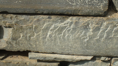

Here is another example of plumose structures, only in this example we see concentric ribs, also known as arrest lines.


Many plumose structures in the Thoroughfare Gap area. Plumose structures record fracture propagation direction in rocks. These structures are a feather-like pattern of ridges and grooves on the fracture surface. Below we can see a few examples of how they can be identified.


Here is another example of plumose structures, only in this example we see concentric ribs, also known as arrest lines.